
Hello, everyone. My name is Daichi, an expert providing the information on the radiation issues in an easy-to-understand manner.
Today I would like to respond to the following question:
– Evacuation orders were declared after the accident of the FDNPP No.1, but how have the evacuation areas changed so far?
(In this article, ‘the FDNPP No.1’ stands for the Fukushima Daiichi Nuclear Power Plant, and ‘the FDNPP No.2’ stands for the Fukushima Daini Nuclear Power Plant.)
This article covers the period: from occurrence of the accident (March 2011) to completion of reorganization of the evacuation areas (August 2013).
The following figures are created mainly based on the figures in the web site of the Fukushima Prefectural Government (in Japanese), therefore if you would like to know more detail, please visit this site or the site of the national government.
Table of contents of this article
- Evacuation orders after the accident of the Fukushima Daiichi NPP (Vol. 1)
- March 11, 2011
- March 12, 2011
- March 15, 2011
- April 21, 2011
- April 22, 2011
- September 30, 2011
- April 1, 2012
- July 17, 2012
- August 10, 2012
- December 10, 2012
- March 22, 2013
- March 25, 2013
- April 1, 2013
- May 28, 2013
- August 8, 2013
- Summary
I have been involved with the radiation-relevant issues, like the policy on the decontamination activities and the management of the Interim Storage Facility, after the accident of the Fukushima Daiichi Nuclear Power Plant in 2011.
I received a doctorate in the field of radiation, while working in Fukushima.
Evacuation orders after the accident of the Fukushima Daiichi NPP (Vol. 1)
March 11, 2011
The first evacuation order was declared on March 11, 2011, when the earthquake occurred.
The state of nuclear emergency was declared, based on the Act on Special Measures Concerning Nuclear Emergency Preparedness, for the FDNPP No.1, followed by evacuation orders within 3km radius from the FDNPP No.1, as well as shelter-in-place order between 3 to 10km radius from the FDNPP No.1 (the figure below).
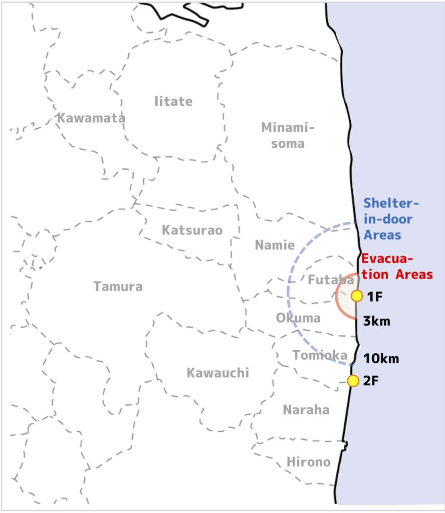
↑March 11, 2011
March 12, 2011
On the next day, March 12, the state of nuclear emergency was declared, based on the same Act, for the FDNPP No.2 and the national government declared evacuation order within 10km radius from the FDNPP No.2.
On the other hand, regarding the FDNPP No.1, evacuation order was expanded from 3km to 20km radius, taking account of the situation of the nuclear reactors (the figure below).
↑March 12, 2011
March 15, 2011
Moreover, three days later, in March 15, shelter-in-place order was declared, between 20 and 30km radius from the FDNPP No.1 (the figure below).
↑March 15, 2011
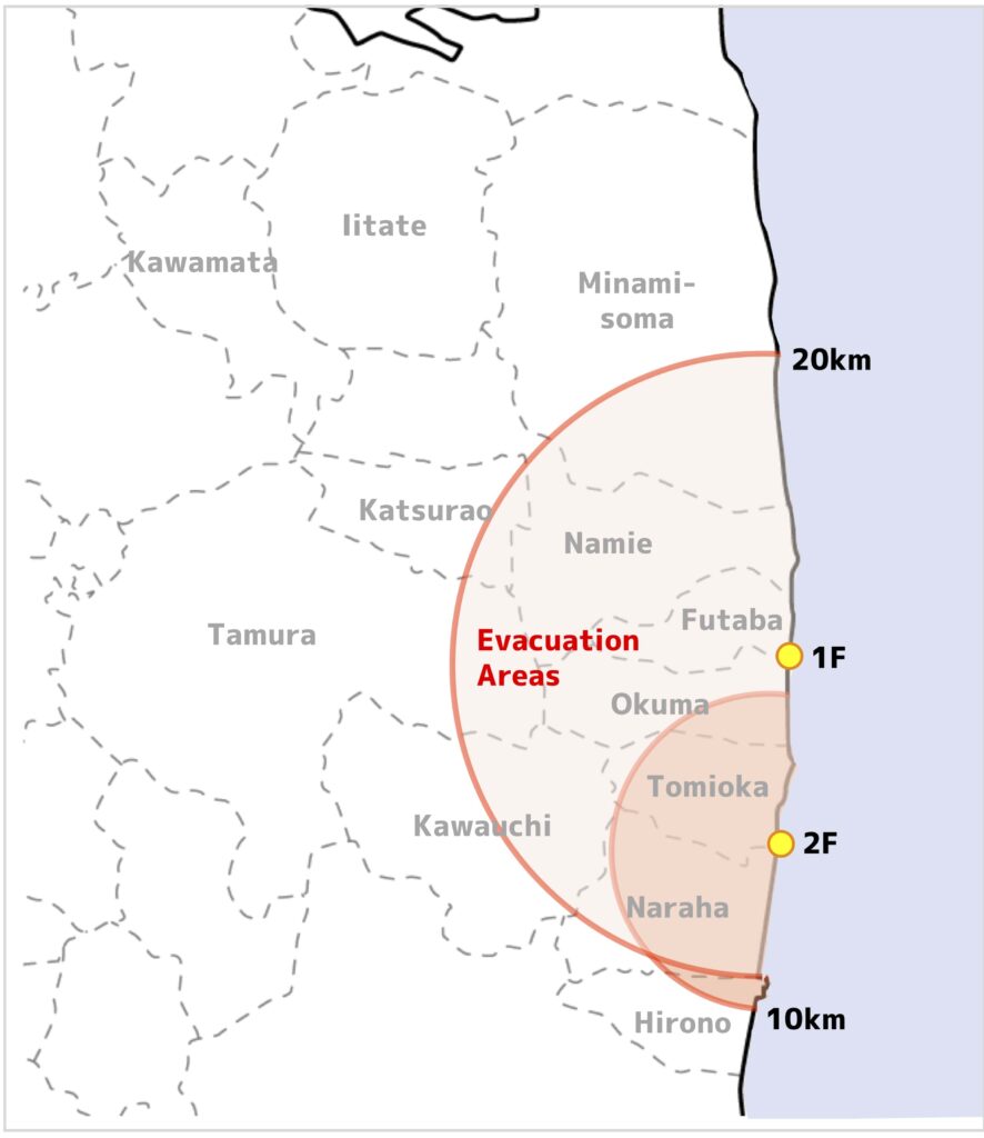
April 21, 2011
In April, taking account of situation of the FDNPP No.2, that it was unlikely for a severe accident to happen, the evacuation order was decreased from 10km radius into 8km radius.
As a result of this, areas of the evacuation orders changed into 20km radius from the FDNPP No.1 (the figure below).
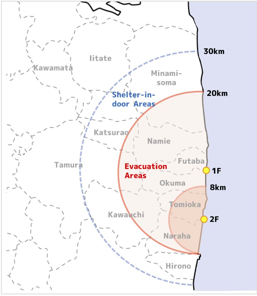
↑April 21, 2011
April 22, 2011
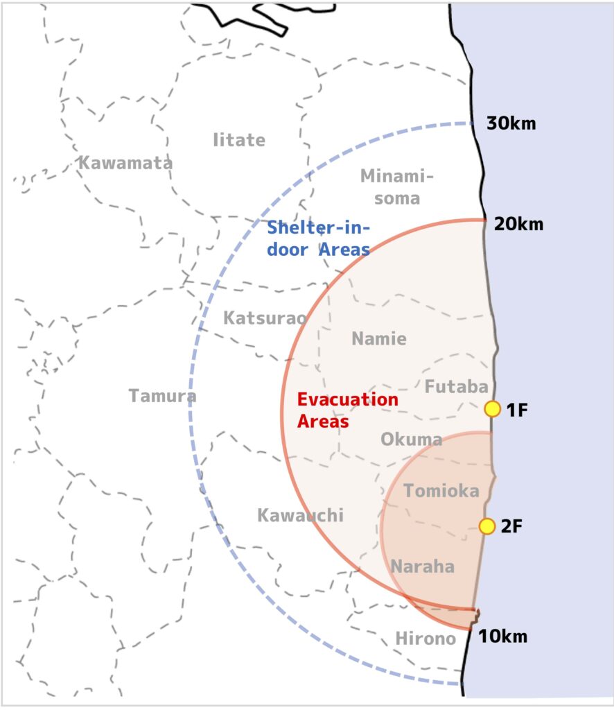
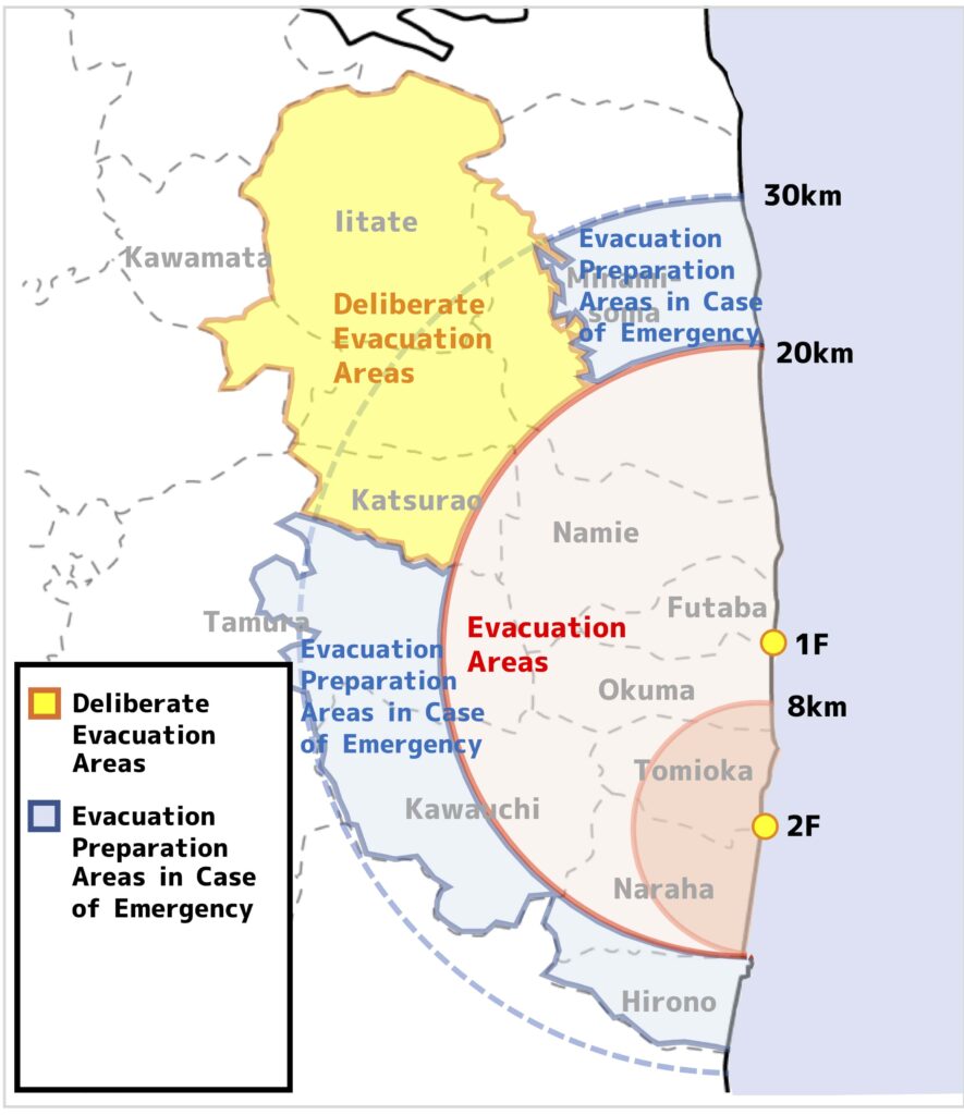
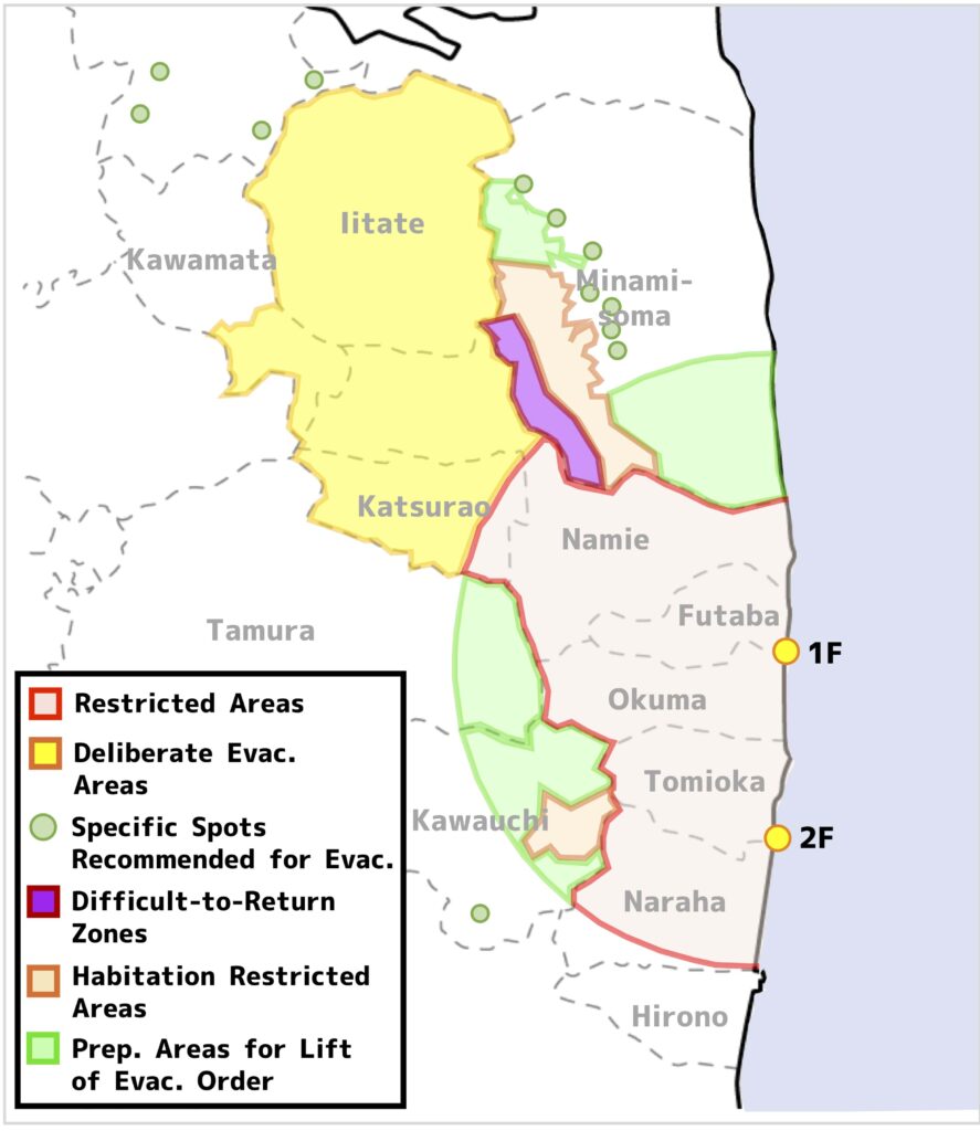
However, it became apparent, that there were areas where estimated exposure dose was higher than other areas, in the northwest of the FDNPP No.1, even in areas farther than 20km radius from the FDNPP No.1.
Therefore, the areas were designated by the national government, as the ‘Deliberate Evacuation Areas’, where the cumulative annual exposure dose after the accident could be possibly more than 20mSv.
In the areas, it was deemed that it was favorable for the public to evacuate within 1 month after the designation.
In addition, based on the shelter-in-place areas at the day, the ‘Evacuation Preparation Areas in Case of Emergency’ were designated.
It might be found out, that regarding the Tamura City, the Kawauchi Village and the Hirono Town, the borders between the areas look complicated, unlike the Minamisoma City.
With regard to the Tamura City, the border corresponded to the border between the Miyakoji district (ex-Miyakoji Village) and other districts, and with regard to the Kawauchi Village and the Hirono Town, the borders were set in order for the whole town and village to be included in the areas.
In the Evacuation Preparation Areas in case of Emergency, it was not required for all residents to evacuate, but at that time situation of the FDNPP No.1 was not able to be regarded as stable.
Taking account of the situation as well, that there was possibility to need to take necessary measures urgently including evacuation, evacuation of expectant mother and voluntary evacuation of other people were recommended (the figure below).
↑April 22, 2011
On the same day, the areas within 20km radius from the FDNPP No.1, including sea area as well, was designated as the Restricted Areas based on the Basic Act on Disaster Countermeasure, where controlled access or exclusion order can be applied to (the figure below).
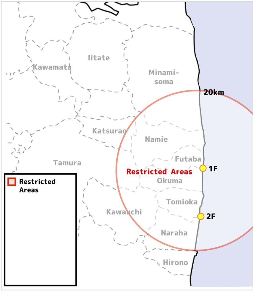
↑April 22, 2011
Below is the integrated map of the evacuation orders as of April 22, 2011.
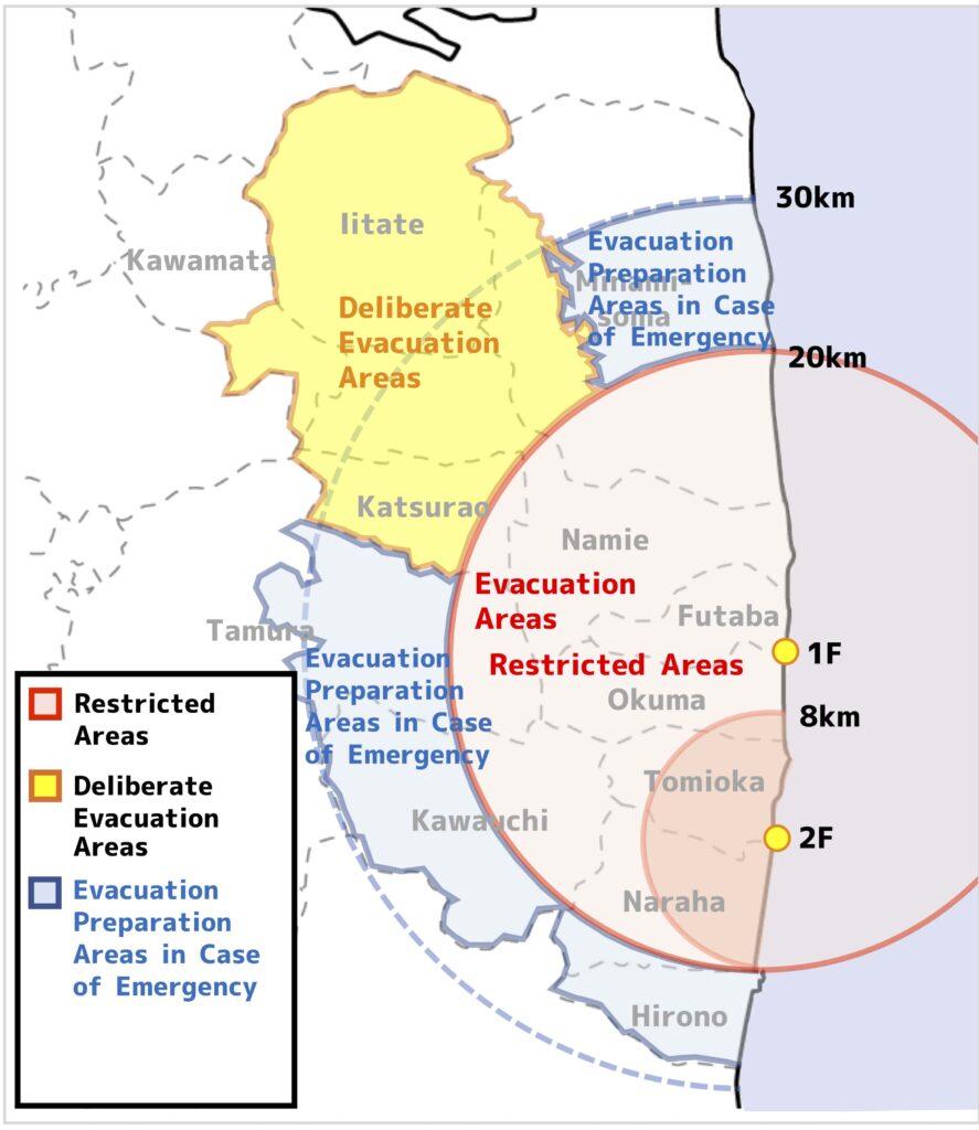
↑April 22, 2011
September 30, 2011
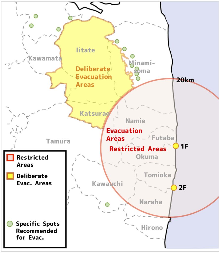
Moreover, it became apparent, in the wake of detail monitoring of air dose rate, that other than existing evacuation areas and the Deliberate Evacuation Areas, there were points, where cumulative exposure dose within 1 year after the accident, could exceed 20mSv/y.
Therefore, the national government set up the ‘Specific Spots Recommended for Evacuation’, point-by-point basis, and supported for the people in the spots to evacuate.
At that time the evacuation areas became largest and they expanded in 12 municipalities excluding the Specific Spots Recommended for Evacuation (13 municipalities when the Specific Spots Recommended for Evacuation are included) (the figure below).

↑September 30, 2011 (Before lift of the designation of the Evacuation Preparation Areas in Case of Emergency)
On September 30, 2011, the designation of the Evacuation Preparation Areas in Case of Emergency was lifted, because it was regarded that safety of facilities of the FDNPP No.1 were secured (the figure below).
↑September 30, 2011 (After lift of the designation of the Evacuation Preparation Areas in Case of Emergency)
April 1, 2012
At the end of the year 2011, the national government evaluated, that the nuclear reactors of the FDNPP No.1 had become stable, and the safety of the nuclear power plant was secured as a whole (Reference: the 22nd Nuclear Emergency Response Headquarters (in Japanese)).
The national government published the policy, that the designation of the Restricted Areas, based on the Basic Act on Disaster Countermeasure would be lifted, and the evacuation areas would be redesigned into new 3 evacuation areas, based on the annual cumulative dose (The Difficult-to-Return Zone, the Habitation Restricted Areas, the Preparation Areas for Lift of Evacuation Order).
This policy intended more detailed measures to be introduced, according to the estimated exposure dose, even the evacuation orders were still in place, in contrast with the previous policy, which set up the evacuation areas simply based on the distance (especially within 20km radius from the FDNPP No.1) from the nuclear power plants.
On April 1st, 2012, based on the above-mentioned policy, the part of the Kawauchi Village was re-designated as the as the Habitation Restricted Areas and the Preparation Areas for Lift of Evacuation Order.
On the same day, the part of the Tamura City was re-designated as the Preparation Areas for Lift of Evacuation Order.
On April 16, the Minamisoma City was re-designated as all 3 kinds of evacuation areas (the figure below).
↑April 1, 2012 (The re-designation of the Minamisoma City was April 16)
July 17, 2012
After that the re-construction and re-designation of the evacuation areas continued, based on the interaction with relevant municipalities and other stakeholders.
On July 2012, the Iitate Village, which was designated as the Deliberate Evacuation Areas, was re-organized into 3 evacuation areas (the figure below).
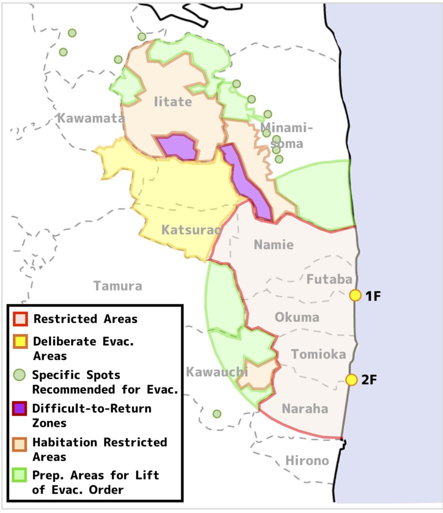
↑July 17, 2012
August 10, 2012
On August 10, the Naraha Town, most of which was designated as the Restricted Areas, was re-designated as the Preparation Areas for Lift of Evacuation Order (the figure below).
↑August 10, 2012
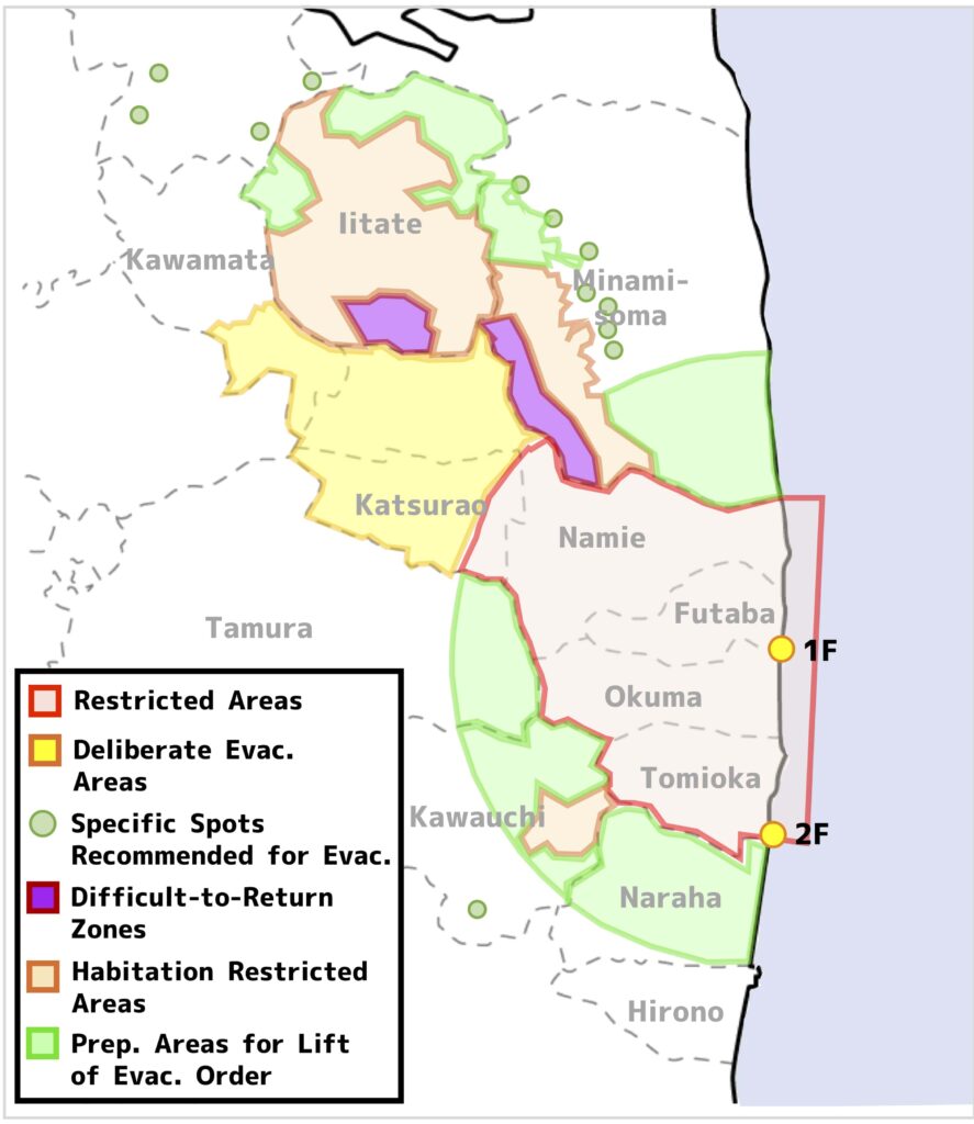
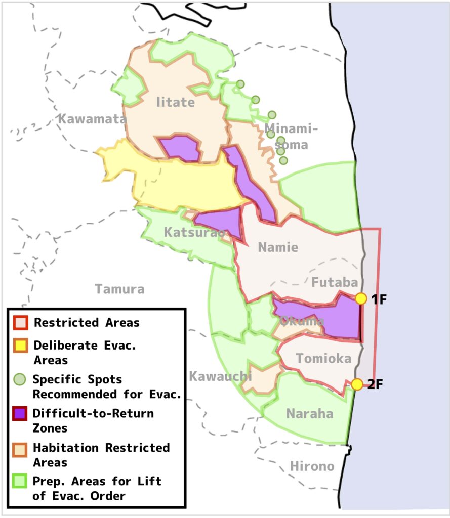
December 10, 2012
On December 10, 2012, the Okuma Town, whose whole area was designated as the Restricted Areas, was re-organized into 3 evacuation areas (the figure below).
↑December 10, 2012
March 22, 2013
In December 2012, designations of the Specific Spots Recommended for Evacuation in the Date City and the Kawauchi Village were lifted, and on March 22, 2013, the Katsurao Village, which was designated as the Restricted Areas and the Deliberate Evacuation Areas, were re-organized into 3 evacuation areas (the figure below).
↑March 22, 2013
March 25, 2013
On March 25, 2013, three days later after the re-organization of the Katsurao Village, the Tomioka Town, whose whole area was designated as the Restricted Areas, was re-organized into 3 evacuation areas (the figure below).
↑March 25, 2013
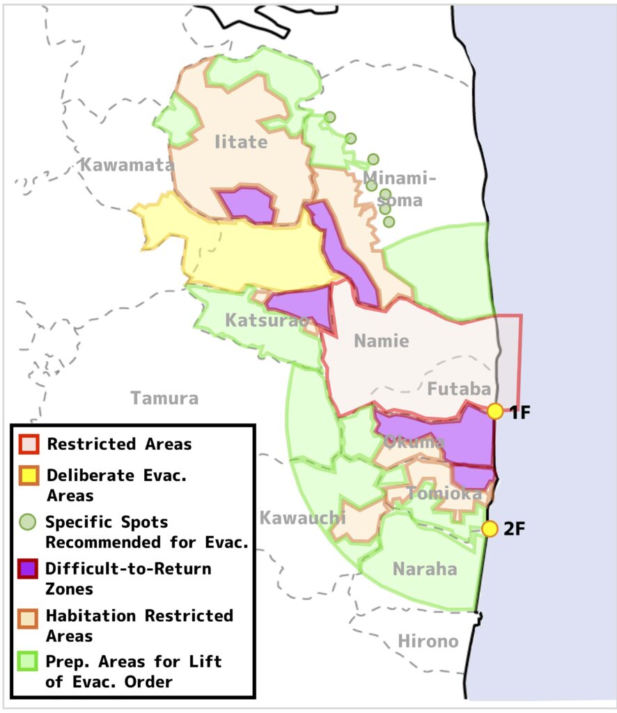
April 1, 2013
On April 1, 2013, the Namie Town, which was designated as the Restricted Areas and the Deliberate Evacuation Areas, was re-organized into 3 evacuation areas (the figure below).
↑April 1, 2013
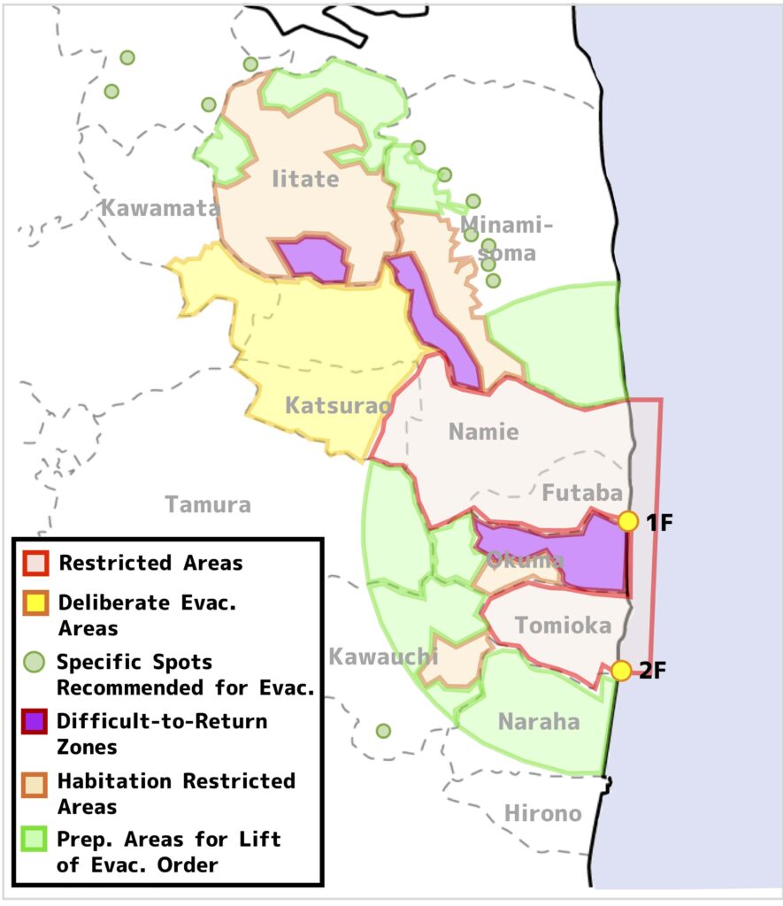
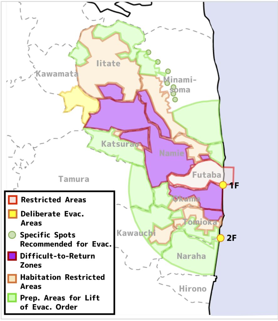
May 28, 2013
On May 28, most of the Futaba Town was re-categorized as the Difficult-to-Return Zone, and the rest of the town was designated as the Preparation Areas for Lift of Evacuation Order (the figure below).
↑May 28, 2013
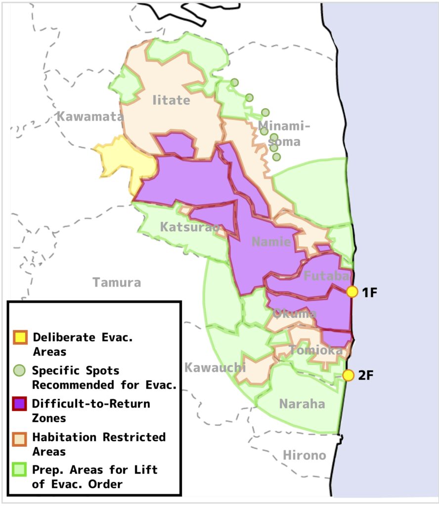
August 8, 2013
On August 8, the Kawamata Town, which was categorized as the Deliberate Evacuation Areas, was re-organized into the Habitation Restricted Areas and the Preparation Areas for Lift of Evacuation Order.
Then re-organization process was completed and all the Restricted Areas and the Deliberate Evacuation Areas were re-categorized into the new three evacuation areas: the ‘Difficult-to-Return Zone’, the ‘Habitation Restricted Areas’ and the ‘Preparation Areas for Lift of Evacuation Order’ (the figure below).
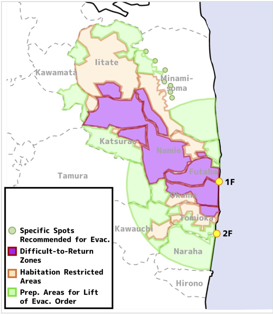
↑August 8, 2013
The specific difference between three areas (the Difficult-to-Return Zone, the Habitation Restricted Areas and the Preparation Areas for Lift of Evacuation Order) and their changes over time will be elaborated in this article.
Summary
This article covers the transition of evacuation areas after the accident of the FDNPP No.1 with time, especially focusing on the period of time, from the occurrence of the accident (March 2011) to the completion of reorganization of the evacuation areas (August 2013).
The evacuation orders were declared on the date of the earthquake (March 11, 2011) onward, but shortly after the accident, they were basically declared based on distance from the nuclear power plants.
As more specific condition for radioactive contamination became apparent, also taking account of the progress of decommissioning of the FDNPP No.1, the evacuation areas were reorganized in a step-by-step manner, based on estimated dose to people.
By the way, above-mentioned contents are summarized in the following videos.
It would be appreciated to visit them at your convenience.
– Japanese version
– English version
You can read the same article in Japanese here.
Thank you very much for reading this article.
See you next time!


コメント